 Filter: Categories of Wisconsin Historical Images
Filter: FORMAT_DIMENSIONS of 26 x 50 cm., on sheet 32 x 57 cm.
Filter: Categories of Wisconsin Historical Images
Filter: FORMAT_DIMENSIONS of 26 x 50 cm., on sheet 32 x 57 cm.

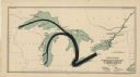
| Date: | 1923 |
|---|---|
| Description: | This map includes an explanation that reads: "This chart shows the movement of barley on the Great Lakes, St. Lawrence River, and New York State Barge Cana... |

| Date: | 1923 |
|---|---|
| Description: | This map shows major cities surrounding the Great Lakes. Portions of Minnesota, Iowa, Illinois, Indiana, Ohio, Michigan, New York, Vermont, Massachusetts,C... |

| Date: | 1923 |
|---|---|
| Description: | This map includes an explanation that reads: "This chart shows the movement of corn on the Great Lakes, St. Lawrence River, and New York State Barge Canal ... |

| Date: | 1923 |
|---|---|
| Description: | This map includes an explanation that reads: "This chart shows the movement of grain on the Great Lakes, St. Lawrence River, and New York State Barge Canal... |

| Date: | 1923 |
|---|---|
| Description: | This map includes an explanation that reads: "This chart shows the movement of oats on the Great Lakes, St. Lawrence River, and New York State Barge Canal ... |
| Date: | 1923 |
|---|---|
| Description: | This map shows the movement of anthracite coal throughout Minnesota, Wisconsin, Ontario, Quebec, Michigan, Illinois, Indiana, and New York. Iowa, Vermont,... |
If you didn't find the material you searched for, our Library Reference Staff can help.
Call our reference desk at 608-264-6535 or email us at: